
It has been an unforgiving winter across the eastern United States so far. The relentless onslaught of Arctic blasts kept temperatures below freezing and supercharged multiple big stormscovering states as far south as the Gulf Coast in the record-breaking snow and ice. Soon, however, this trend will finally be broken.
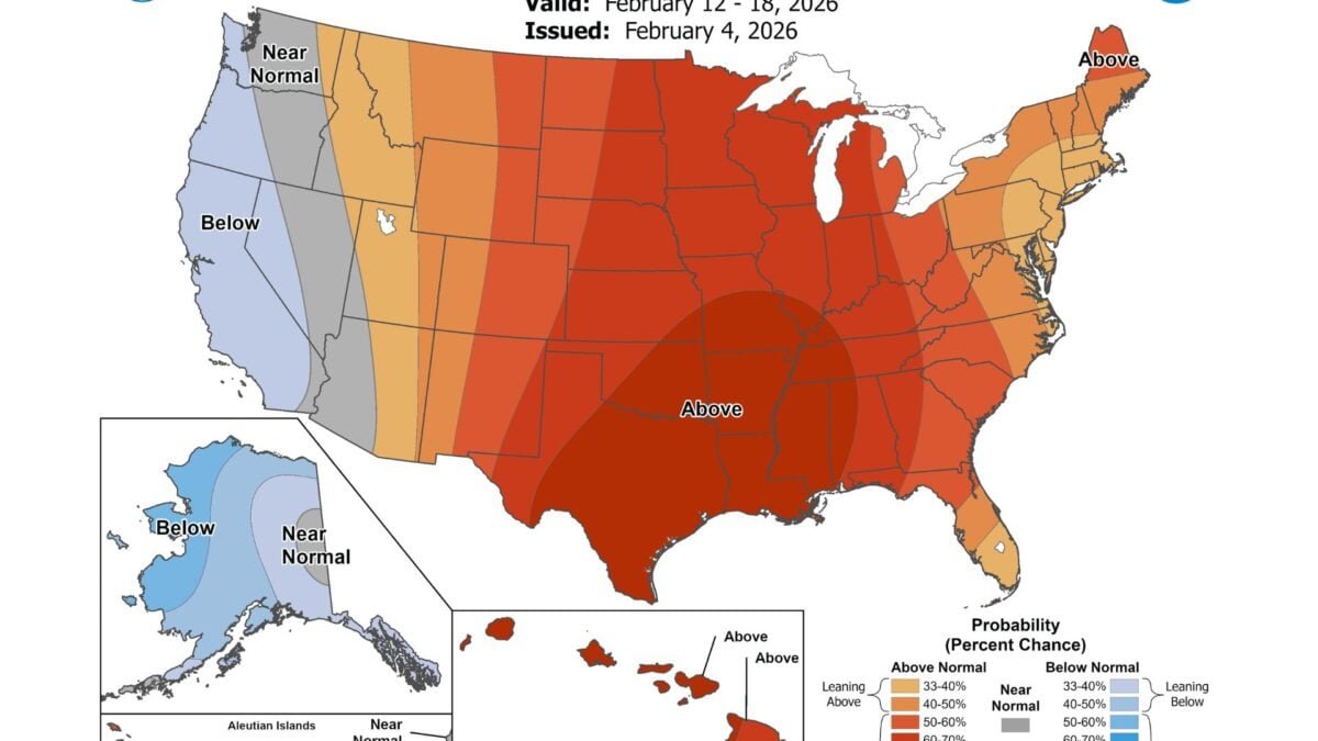
The latest temperature forecast map from the National Weather Service’s Climate Prediction Center, released Wednesday, showing that most of the country can expect to see above-average temperatures from February 12 to 18. The only exception is the West Coast, with California, Oregon, Washington, Nevada, and the western half of Arizona more likely to see below-average or normal temperatures.
To be clear, this outlook map does not show actual temperature forecasts for the next two weeks. However, it indicates the likelihood that the average temperature will be above normal, near normal, or below normal based on forecast modeling. However, the map is a good sight, as millions across the country face episodes of life-threatening cold since early December.
Of course, there is a catch. While this forecast certainly gives us something to look forward to, the near-term forecast shows that another Arctic blast is on the way, threatening to send temperatures plummeting across the East over the weekend.
Another teeth-chattering weekend
NWS forecasters today Tracking a storm that is expected to spread light winter rain over parts of the Mid-Atlantic today before gradually moving up the southeast coast. This system may intensify as it encounters the warm waters of the Gulf Stream tonight, but by then, it should move quickly away from the coast.
Although this storm will not have much effect on the precipitation field, it will help usher in another surge of Arctic air released by the disrupted polar vortex. Forecasters expect sub-freezing temperatures to sweep through the East on Friday morning, reaching south of the Florida Panhandle. In fact, it may be the coldest weekend of the winter so far for much of the Northeast.
As of Thursday afternoon, the NWS has issued severe cold watches for much of the Northeast, from Pennsylvania to northwestern Maine. This region can expect dangerous wind chills as low as -35 degrees Fahrenheit (-37 degrees Celsius). Such conditions can be fatal, leading to frostbite or hypothermia in a few minutes. The agency urged residents to limit their time outside this weekend but stressed the importance of wearing layers and not leaving any skin on if you must go out.
A cold weather advisory has also been issued for much of Florida, as well as freeze warnings for northern Florida and the southeast corner of Georgia.
It’s almost the end of winter
Regardless of what the groundhog is SAYSmeteorological winter is almost over. The cold weather over the weekend will likely be the last before we move into warm weather, so it may start to feel like spring in the next few weeks.
However, it is too early to tell what the rest of February will bring. This month is the is notorious for its wild local and regional temperature swings, even when the average temperature rises. That said, short bursts of cold air and late-season storms may still form.
Temperatures are forecast to warm up across much of the East next week, so hopefully that fact will help residents get through this dreary weekend. Winter may not be over yet, but it looks like its grip on the region is finally starting to soften.


